Tijarafe BeachSpain Beach Guide
Black sand, sheer cliffs, and absolute Atlantic solitude
About
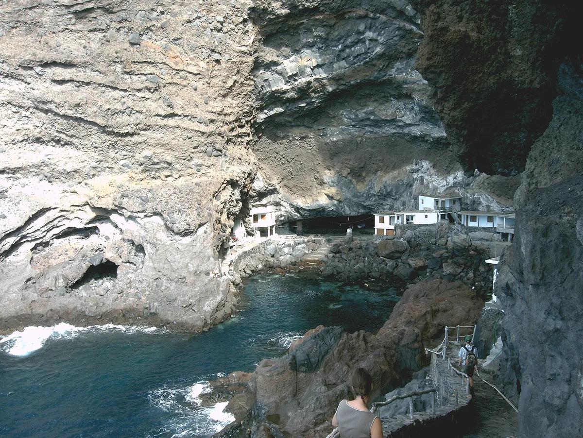
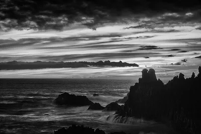
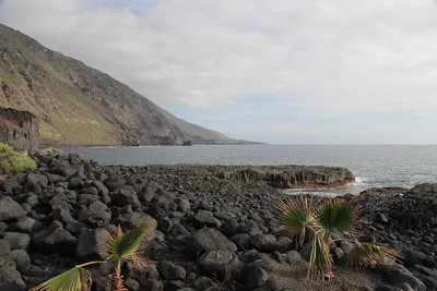
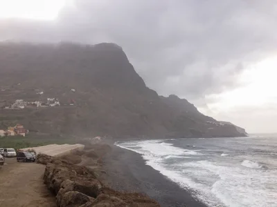
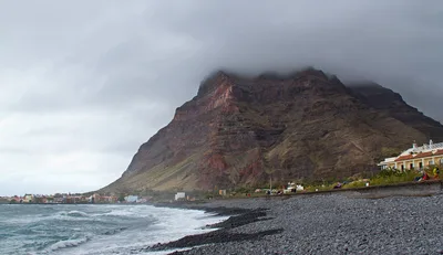
Playa de Tijarafe sits at the foot of vertiginous cliffs on La Palma's northwest coast, reachable only after a demanding descent from Tijarafe village. The beach is a raw mix of boulders and black volcanic sand, backed by dramatic rock faces and open to the deep blue Atlantic. There are no facilities, no lifeguard, and no other visitors on most days — just wind, waves, and the sound of the ocean. It's wild in the truest sense: exposed, elemental, and completely unmanaged. The isolation is the point.
How to get there
The only way to reach Playa de Tijarafe is on foot from Tijarafe village — there is no road access and no parking at the beach itself. Leave your vehicle in the village and follow the track down to the coast. The descent is vertiginous and the path can be slippery, so solid hiking footwear is non-negotiable. There is no entry fee.
Who it's for
For couples
If you and your partner are comfortable with a demanding hike and have solid footwear, the complete solitude here is rare — you'll almost certainly have the entire black sand and boulder beach to yourselves. It's not a romantic stroll; it's a shared adventure for couples who want something genuinely off the map.
For families
Playa de Tijarafe is not suitable for families with children. The descent is vertiginous, the track becomes dangerous when wet, there are no facilities whatsoever, and swimming is dangerous. Families should look elsewhere on La Palma for a beach day.
Our take
Playa de Tijarafe is not a beach you visit for a swim or a sunbathe — the water is dangerous and you should not enter it under any circumstances. That said, for those who are fit, sure-footed, and equipped with proper hiking footwear, the descent rewards with something genuinely rare: a wild, boulder-strewn black sand shore on La Palma's isolated northwest coast, with no one else around. The vertiginous track is the price of admission, and it's a serious one — anyone with vertigo or mobility concerns should stay away. Come between June and September, when the track is dry and the Atlantic is calmer. This is a place for solitude-seekers and landscape photographers who understand the risks and respect them. Go prepared, go in the right season, and don't go near the water.
What to do
Before or after the hike, the Mirador del Barranco de Jurado sits just 0.2km away and offers dramatic views over the ravine landscape. A short walk further brings you to the Mirador Panorámico de Morro de las Salinas, another sweeping coastal viewpoint. The nearby ruins of Porís de Candelaria, 0.7km away, add a layer of history to the walk. For a longer day, Caldera de Taburiente National Park — a massive volcanic caldera with deep gorges and laurel forest — is roughly 10km away.
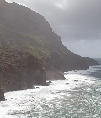
The cliff-top viewpoint before the descent gives you the full drama of the vertiginous drop to the black volcanic shoreline below — shoot wide to capture the scale.
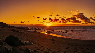
At beach level, the contrast of dark boulders and black sand against the deep blue Atlantic is the defining image; position low among the rocks for foreground texture. The Mirador del Barranco de Jurado, just 0.2km away, adds a classic ravine panorama to your set without the full descent.
Where to eat
There are no restaurants or food vendors at the beach, so pack everything before you descend. Back up in the area, Ciao Ciao and Pizzeria La Fuente both serve pizza and are around 2.1–2.2km from the beach. Los Olivos is another option at 2.2km, while Muralla, about 3.5km away, offers regional Canarian cooking.
Where to stay
The closest accommodation options are a short drive away in the direction of Tazacorte and Puerto Naos. Hotel Eden is 7.1km from the beach, with Residencial Tazacorte City and Benahoare both around 7.3–7.4km. If you prefer a self-catering setup, Villa Puerto Naos and Apartments Roque are further south at roughly 13km.
Photography
The most striking shots come from the cliff edge above the beach, where the scale of the descent and the contrast between black volcanic rock and deep blue Atlantic water is at its most dramatic — early morning light from the east catches the cliff faces well. Down at beach level, the mix of boulders and black sand against the open ocean makes for powerful wide compositions, best in the golden hour before the midday glare flattens the texture.
Good to know
Do not enter the water. The northwest coast is fully exposed to Atlantic swells and swimming here is dangerous — stay well clear of the shoreline. The descent track is vertiginous and is not suitable for anyone with vertigo; after rain it becomes slippery and significantly more hazardous, so solid hiking footwear is essential. There is no lifeguard, no shade, and no facilities of any kind — carry everything you need, including water. Avoid visiting between October and March, when heavy Atlantic swells and wet conditions make both the track and the shoreline genuinely dangerous.
Map
Nearby places
Ciao Ciao
Pizzeria La Fuente
Los Olivos
Muralla
La Marina
Hotel Eden
Residencial Tazacorte City
Benahoare
Villa Puerto Naos
Apartments Roque
Mirador del Barranco de Jurado
Mirador Panorámico de Morro de las Salinas
Porís de Candelaria
Tijarafe village
Caldera de Taburiente National Park
Roque de los Muchachos Observatory
Things to see around Tijarafe
Tijarafe village
Traditional Canarian village with church and views over the northwest coast.
Caldera de Taburiente National Park
Massive volcanic caldera and national park with dramatic gorges and laurel forest.
Roque de los Muchachos Observatory
World-class astronomical observatory at 2,426 m on the Caldera de Taburiente rim.
Frequently asked
The information on this page is provided for guidance only and may evolve. Access conditions, safety and infrastructure can change without notice. Always check official sources before traveling.
Nearest beaches
Other wild beaches in Canary Islands
More beaches in Canary Islands
Reviews of this beach
- No reviews yet, what a shame — leave yours and share your experience.
Photo credits
Sources and licenses for the photos shown above.
- Photo 1 — Hans-Peter Balfanz · source · CC BY-SA 3.0
- Photo 2 — Frank Vincentz · source · CC BY-SA 3.0
- Photo 3 — Frank Vincentz · source · CC BY-SA 3.0
- Photo 4 — Syrio · source · CC BY-SA 4.0
- Photo 5 — Syrio · source · CC BY-SA 4.0
- Photo 6 — Frank Vincentz · source · CC BY-SA 3.0