Escalera BeachSpain Beach Guide
Cliff-cut staircase, golden sand, zero footprints
About
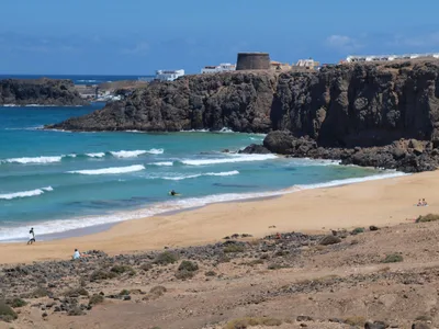
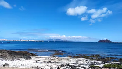
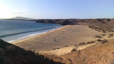
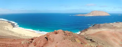
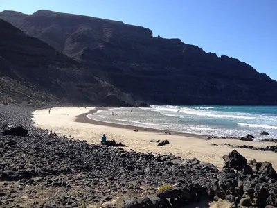
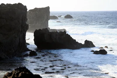
Playa de Escalera sits on the north coast of Fuerteventura, tucked beneath basalt cliff walls that block the relentless trade winds and deliver a pocket of unusual calm in an otherwise exposed stretch of coastline. A concrete staircase cut directly into the cliff is the only way down — there's no signage, no path marker, no hint from above that golden sand and blue water wait below. The beach is empty on almost every visit; this is local-only knowledge, the kind of place that doesn't appear on resort maps. The basalt walls give the cove a raw, sculptural quality — dark rock framing the golden sand and open blue sea beyond. It's wild in the best and most literal sense: no facilities, no lifeguard, no noise except the Atlantic.
How to get there
Reach Playa de Escalera by car from the El Cotillo area via the cliff-top road — allow around 10 minutes from that direction. There is no formal parking; vehicles are left at the cliff edge, so take care on uneven ground. Once at the top, the concrete staircase cut into the cliff face is your only route down. The beach has no services of any kind — plan accordingly.
Who it's for
For couples
The isolation is the draw — an empty cove with golden sand, blue water, and basalt walls that feel like a private amphitheatre. It rewards couples willing to make the climb down and carry their own picnic.
For families
The steep concrete staircase makes this beach completely inaccessible for young children, pushchairs, or anyone with limited mobility — it's honestly not a family beach. The Playa de El Cotillo lagoons, just 3 km away, are a far safer and more practical choice for families.
Our take
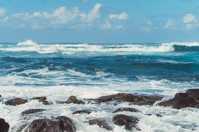
Swimming here is rated moderate, but that rating applies only to the calmer summer months — from November through February, north-coast swells make entering the water genuinely dangerous, and you should stay out. Outside those months, the unusual calm created by the basalt cliff walls makes this one of the more approachable spots on Fuerteventura's north coast, though you're always swimming without a lifeguard and without any backup. The staircase is the price of admission: steep, concrete, and slippery when wet — if conditions are damp, turn around. What you get in return is golden sand, blue water, and the kind of empty beach that feels increasingly rare. No facilities means you carry everything in and out; treat that as a filter, not an inconvenience. The Mirador Playa del Aguila at 0.2 km makes a logical first stop to scout conditions from above before committing to the descent. Come in summer, come prepared, and come early.
What to do
Just 0.2 km away, the Mirador Playa del Aguila offers a cliff-top viewpoint worth a stop before or after your descent. A short walk of around 0.6 km brings you to Punta Mallorquín, a dramatic headland on this rugged north coast. For a contrast in mood, the Playa de El Cotillo lagoons — reef-enclosed calm waters north of the Torre del Tostón — are about 3 km away and make a natural second stop on the same day. The Torre del Tostón ruins are also at that 3 km mark and worth a quick look.
The concrete staircase itself — shot from mid-descent with the blue water framed between dark basalt walls — is the defining image of this beach.
From the sand, turn back and shoot upward: the cliff walls converging overhead with a strip of sky above is a composition you won't find at any signposted beach on the island.
Where to eat
The nearest cluster of restaurants sits around 3.6–3.7 km away, back toward El Cotillo. El Roque de los Pescadores and NaNa are both at roughly 3.6 km, alongside Teperino for Italian and pizza. La Marée Haute, offering barbecue and pizza, is a little further at 3.7 km — pack a lunch for the beach itself, because there is absolutely nothing on-site.
Where to stay
Cotillo House, about 4 km from the beach, is the closest base and keeps you well-positioned for an early-morning visit before anyone else finds the staircase. Cotillo Lagos is a little further at 4.6 km. If you prefer a rural setting, Hotel Rural Restaurante Mahoh is around 11 km away.
Photography
The best shot is from the top of the staircase looking down — basalt cliff walls framing the golden sand and blue water in a natural corridor that no wide-angle lens can do justice to. Arrive in the morning when the light hits the cliff face directly and the beach is at its most empty.
Good to know
The staircase can be slippery when wet, so wear shoes with grip and take your time on the descent. North-coast swells make swimming inadvisable from November through February, and the staircase becomes more hazardous in wet winter conditions — avoid those months entirely. Bring everything you need: water, sun protection, food — there is nothing on-site and no shade beyond the cliff walls. The nearest laptop-friendly café, Cannabis, is about 3.8 km away, but once you're down on that sand, you'll want to stay offline anyway.
Map
Nearby places
El Roque de los Pescadores
Olivo corso
Teperino
NaNa
La Marée Haute
Mirador Playa del Aguila
Punta Mallorquín
Barranco de los Encantados o de los Enamorados
Things to see around La Oliva
Playa de El Cotillo lagoons
Reef-enclosed calm lagoon beaches north of the Torre del Tostón.
Torre del Tostón
Corralejo Dune Park
2,700-hectare protected dune system with white sand beaches.
Frequently asked
The information on this page is provided for guidance only and may evolve. Access conditions, safety and infrastructure can change without notice. Always check official sources before traveling.
Nearest beaches
Other wild beaches in Canary Islands
More beaches in Canary Islands
Reviews of this beach
- No reviews yet, what a shame — leave yours and share your experience.
Photo credits
Sources and licenses for the photos shown above.
- Photo 1 — Pille Kirsi · source · Pexels License
- Photo 2 — Maria Florencia Torres · source · Pexels License