Koh Nang Yuan Beach
Three islets, twin causeways, one unforgettable Gulf view
About
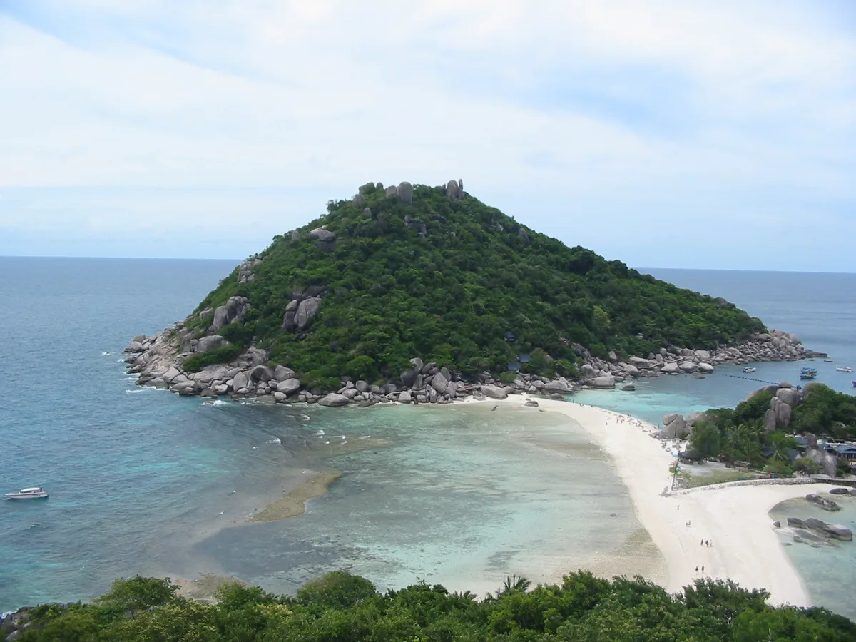
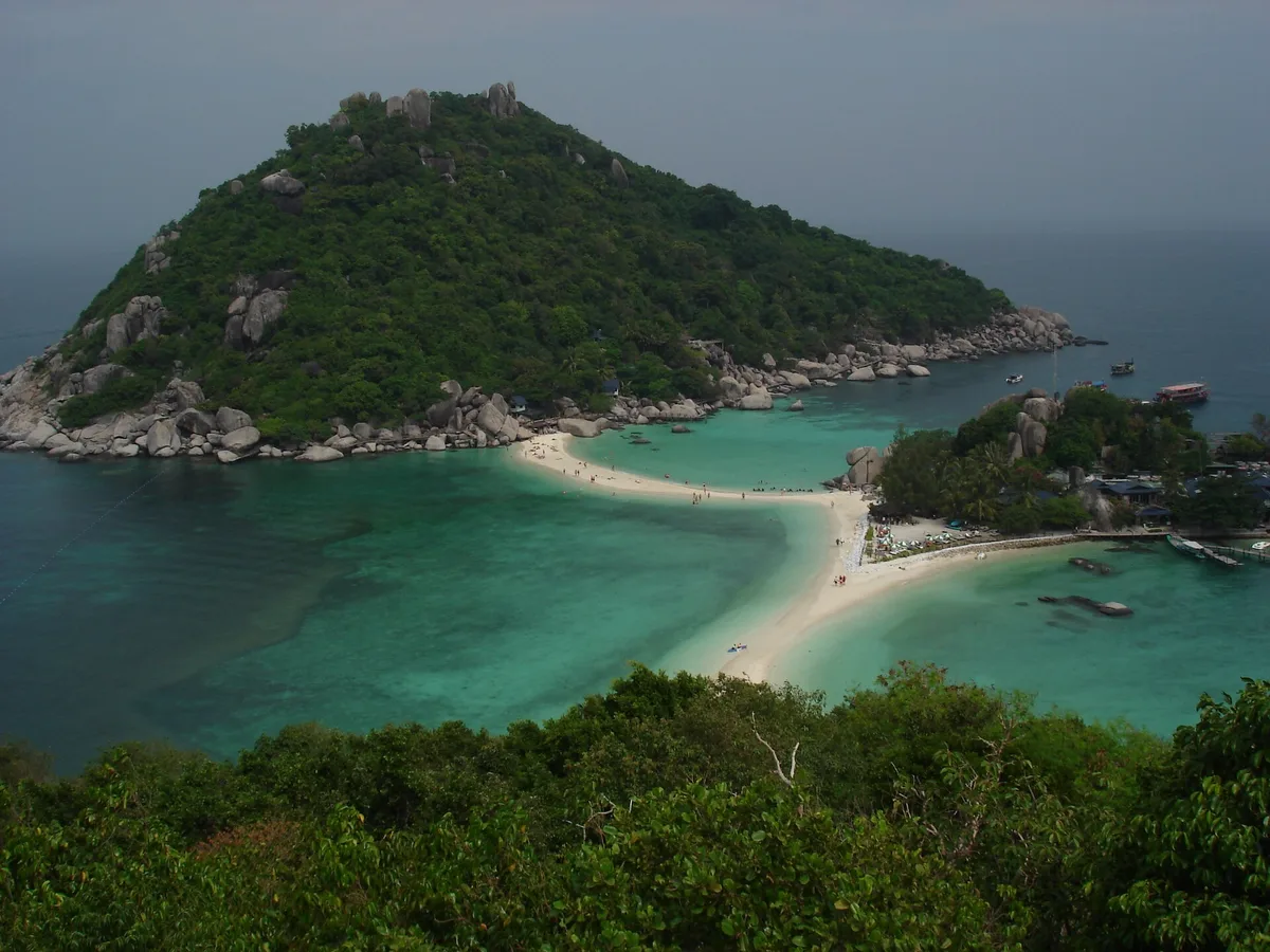
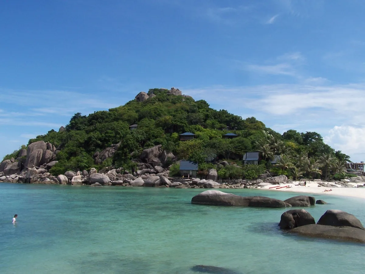
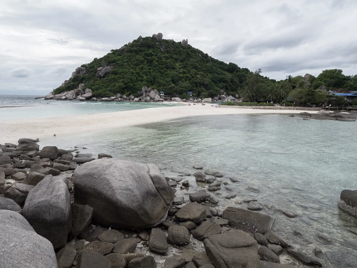
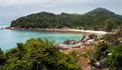
Koh Nang Yuan sits just off Koh Tao's northwest tip — three tiny islets stitched together by two slender white-sand causeways that rise from turquoise water like a geography lesson in miniature. The beach itself stretches barely 150 metres, but the setting punches far above its size: coral reef wraps the islets, the water runs a clear turquoise, and a steep hilltop viewpoint frames the whole formation from above. It's busy for good reason — this is one of the Gulf of Thailand's most photographed spots — so arrive early if you want the causeways to yourself. A strict no-plastic-bottle policy and a mandatory entry fee keep the reef and sand in better shape than most.
How to get there
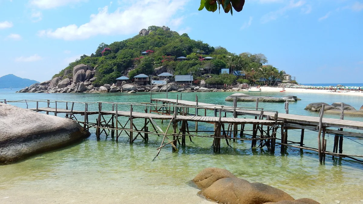
Koh Nang Yuan is boat-only — there is no road, no bridge, and no other way in. Catch a daily boat from Mae Haad pier on Koh Tao; the crossing takes around 15 minutes. An entry fee is charged at the island; it's waived if you're staying at Koh Nang Yuan Dive Resort. Plastic bottles are confiscated at the gate, so decant your water before you board.
Who it's for
For couples
The romantic vibe here is earned, not marketed — two people crossing a white-sand causeway with turquoise water on both sides, then climbing to a hilltop viewpoint at golden hour, is genuinely special. Just book an early boat to get the causeways before the day-trip rush arrives.
For families
Families with older children who can manage rocky terrain and a steep viewpoint trail will enjoy the snorkelling and the dramatic scenery. Note that sandy causeways and rocky paths are not suitable for wheelchairs or pushchairs, and young children will need close supervision near the water's edge.
Our take
Feet in the sand, eyes on the screen
Koh Nang Yuan is safe to swim and snorkel — the water is calm and the reef is the whole point of coming. That said, watch the causeways: they go underwater at high tide, so check conditions before you plan your walk across. The island is genuinely one of the Gulf of Thailand's most striking formations — three islets, two white-sand causeways, turquoise water, and a viewpoint that justifies every step of the climb. It's busy, it charges an entry fee, and it enforces rules that most Thai beaches don't bother with — and the reef and sand are better for it. Skip November and December if you want a reliable crossing; rough seas regularly cancel day-trip boats. Come in the dry season, take the first boat out, climb the viewpoint before the heat peaks, and snorkel the reef before you leave.
What to do
The Ko Nang Yuan Viewpoint, just 0.3 km from the beach, rewards a steep trail with an aerial panorama of the twin causeways and surrounding reef — this is the shot everyone comes for. Snorkelling the coral reef that rings the islets is the other main draw, with clear turquoise water making it easy to spot marine life without going deep. If you want more of Koh Tao, Top Point sits 1.1 km away and Mae Haad Village — the main ferry pier with markets and dive agencies — is 2.5 km across the water.
The Ko Nang Yuan Viewpoint (0.3 km) is the non-negotiable shot — the aerial view of both white-sand causeways flanked by turquoise water is the image that put this island on the map.
At sea level, stand on the causeway itself at low tide for a symmetrical perspective with islets on either side. Early morning light keeps the water colour vivid and the frame clear of other visitors.
Where to eat
There are no restaurants on the island itself, so plan accordingly. Back on Koh Tao, Mango Bay (2.2 km) is the closest option after you return to the main island, and Samatha Restaurant and Coffee Shop (2.4 km) covers post-snorkel coffee and a sit-down meal. Tommy (2.5 km) and Porto Bello Mediterranean Bistro (2.6 km) round out your options if you're staying overnight on Koh Tao.
Where to stay
You cannot sleep on Koh Nang Yuan itself — day-trip only. The closest base on Koh Tao is Dusit Buncha Resort (0.9 km from the beach by boat), followed by Koh Tao Hillside Resort (1.4 km) and Sairee Seaview (1.8 km). Coral Grand Resort (2.1 km) is another solid option if the closer properties are full.
Photography
The hilltop Ko Nang Yuan Viewpoint (0.3 km) delivers the iconic overhead shot of the twin causeways cutting through turquoise water — shoot in the morning before haze builds and before the day-trippers fill the frame. Down at sea level, the causeways themselves photograph best at low tide when the white sand is fully exposed against the turquoise sea.
Good to know
Leave plastic bottles behind before you even step on the boat — the island enforces a hard ban and you will not get them through the entry point. The twin sand causeways are a highlight, but they submerge at high tide, so time your walk across them for low tide. Day-trip boats can stop running in rough November and December seas; always confirm your departure is operating before you book. Overnight stays are not permitted, and last boats leave before sunset — don't miss them.
Map
Nearby places
Mango Bay
Samatha Restaurant and Coffee Shop
Tommy
Brother
Porto Bello Mediterranean Bistro
Dusit Buncha Resort
Koh Tao Hillside Resort
Sairee Seaview
Bow Thong Resort / Palm Leaf Resort
Coral Grand Resort
Things to see around Ko Tao
Ko Nang Yuan Viewpoint
Steep trail to hilltop with aerial view of the twin causeways and surrounding reef
Sairee Beach
Ko Tao's main 2 km beach with dive shops and sunset views
Mae Haad Village
Main ferry pier village with markets and dive agencies
Frequently asked
The information on this page is provided for guidance only and may evolve. Access conditions, safety and infrastructure can change without notice. Always check official sources before traveling.
Nearest beaches


More beaches in Gulf of Thailand

Reviews of this beach
- No reviews yet, what a shame — leave yours and share your experience.
Photo credits
Sources and licenses for the photos shown above.